


Easy Area serves as an intuitive area calculator designed for measuring land area, distance, and perimeters on maps or images with ease. This Android app is equipped with an integrated unit converter that enables users to measure areas and distances in diverse Indian land units, making it exceedingly useful for users in those regions.
Innovative Measurement Techniques
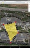
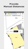
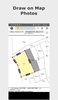
To facilitate precise measurements, Easy Area offers two primary methods: using maps and importing photos. Through the map feature, you can pinpoint a location and delineate the borders of the land, thereby calculating the area or distance effortlessly without prior measurement knowledge. Alternatively, the photo import function allows you to upload images of land or structures and overlay sketches to determine measurements. Providing the initial distance measurement aids in setting an accurate scale ratio, ideal when official boundary measurements are available. This function is exceptionally beneficial for landowners requiring area calculations derived from pre-measured distances.
Advanced Features for Accuracy
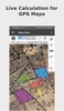
With a focus on accuracy, Easy Area uses coordinate and spherical geometry to ensure precise calculations. The app displays point-to-point distances for mapped lines and offers manual adjustment capabilities for inputting further land borders. Supporting multiple layers allows for concurrent measurements on the same map, with tools to easily add or adjust points.
Versatile Units Converter and Sharing Options
Easy Area features a robust unit converter encompassing both imperial and metric units, along with major Indian units such as Bigha, Vaar, and Marla. This converter permits real-time area conversion, tailored to regional land unit practices. Additionally, you can save and share your measurement data through a link, allowing others to view or update the calculations, making Easy Area an effective tool for collaboration and land management.
Requirements (Latest version)
- Android 5.0 or higher required
Comments
Good service